
David Collette, ’08, went looking for his Viking forebears. He may find one of the most famous warships in Canadian Arctic history.
- By
- January 10, 2018
- CBM - Winter 2018
It’s neither the craziest idea ever hatched in a hot tub nor the only one with unintended consequences. When David Collette, ’08, and his uncle Johann Straumfjord Sigurdson shared a bottle of brennivín, Iceland’s national aquavit, while gazing north at 300 miles of Lake Winnipeg, it seemed like an adventure worth taking. Both Canadians, they knew they descended from Icelanders—hence the caraway-flavored liqueur—and sailing from Manitoba up Hudson Bay, and from there to Iceland in search of their ancestors sounded like fun. The trip would take several weeks. They could look for artifacts and talk to people along the way, collecting oral histories and following Viking sagas.
Six years later, Collette and Sigurdson are planning their fourth expedition, having formed a foundation, joined two exclusive groups of explorers, and traced their ancestors back to Snorri, the first child born to Europeans in North America and the son of Collette’s 26th great-grandmother.
“We know that people from Iceland and Greenland—Vikings—came to Canada around AD 1000,” Collette said. “They settled, explored, and traded until the fifteenth century and then they left, but in a very orderly way. It wasn’t starvation or war that drove them away. But why did they leave and where did they go? Europeans knew about North America long before Columbus and knew how to get here. The basis of our initial quest was: more than 500 years and nobody came. What’s that about?”
“There are facts to be found and pages of history to be written.”
— David Collette
The two men, now minus the alcohol and the moonlight on the water, started to research, and traced their genealogical roots. In the early 1960s, archaeologists proved that Vikings predated Columbus’s “discovery” of North America and had settled in Newfoundland, but there’s still no proof that they came as far as Manitoba, Canada. If there are Viking artifacts along the northern Manitoba shoreline, the best way to find them would be to “travel the route on the deck of a sailboat and see what my ancestors would have seen,” Collette said. The adventure hatched in the hot tub now didn’t look so fanciful.
What has happened along the way is not so much a detour as the unintended consequences of the original idea. “There are facts to be found and pages of history to be written,” Collette said. “When you ask the question, Where am I from? there’s a lot to be learned.”
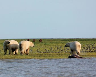
In 2012, the two and their teenaged children went on their first expedition down the Nelson River headed for York Factory, a historic fur-trading port. They equipped a Royal Canadian Navy lifeboat with an engine that had the rowing power of a small Viking boat. They took antique maps and tried to find old trails, but the river had moved and rebounding from the Ice Age had changed the landscape so much that there was nothing to be found. They also missed high tide, which, in true Canadian fashion, is an epic 16-foot event on Hudson Bay. This meant they had to overnight at Port Nelson with, as they discovered, a seal-slaying polar bear. That’s when they realized that “this trip-planning, expedition stuff isn’t like it sounded sitting in a hot tub,” Collette said. “You can die. The Arctic doesn’t mess around. The weather can kill you. The animals can kill you. If you’re stupid, you can get eaten by a polar bear.”
It was also on this initial trip that they came across the history of the Battle of Hudson Bay, a 1697 battle that ranks as one of the 10 most important battles in Canadian history.
In a broadside-to-broadside fight (think Master and Commander, with blood running out of the scuppers and the English captain raising a dismissive glass of wine to French-Canadian bravery), the French-Canadians sank the Royal Navy frigate HMS Hampshire, captured another ship, then beached their own sinking ship. The Hampshire sank, fully loaded and all hands on board. It’s never been found.
Learning about the battle gave Collette and Sigurdson a new idea. If they could find the Hampshire, it would do two things. First, they’d be able to continue what was an increasingly technological and expensive hobby. Second, they’d establish credibility.
Collette is a former Royal Canadian Air Force pilot and an avid solo sailor. A mechanical engineer and a serial entrepreneur, now president of Cincinnati-based walkway safety company Substratum Group, he not only was unintimidated by technology but knew how to talk about satellites and sonar. He could show what a dedicated amateur can do.
He and his uncle joined the Explorers Club and the Royal Canadian Geographic Society. Collette’s daughter Mackenzie is also a member of the Explorers Club. They formed the Fara Heim Foundation to formalize their efforts and have since started putting together expeditions to find the Hampshire.
“It’s findable,” Collette said. “The water isn’t that deep, and it was full of metal. For years, people found cannons, pieces of ships. The Hampshire sank intact, and we can find it.”
From pondering his ancestry, Collette has moved on to a new question: How do you find a boat under the water?
“We want to use the Hampshire expedition to build our reputation for the next phase: find the Vikings,” Collette said. He’s in contact with a scientist who uses space archaeology to look for the foundations of Viking longhouses. It’s a long trip from Iceland to Lake Winnipeg in an oar-powered ship. It’s even longer from a hot tub on the shore to 1,000 years in the past.
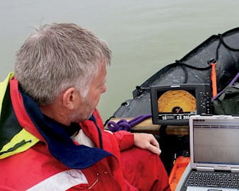
Explorers have always used the latest technology to minimize risks and maximize results. The search for the Northwest Passage added the life-threatening challenge of Arctic weather. The Franklin Expedition left England in 1845, for instance, with 129 men, three years’ worth of preserved food, ships reinforced with iron, and a steam heating system. It was never seen again. Today’s explorers can often prepare for their expeditions—and even do their initial exploration—from a laptop.
Magnetometer
Metal artifacts can be found quickly using magnetometers with a variety of capabilities. These machines have also been miniaturized, making them portable and inexpensive. “The Hampshire was full of cannon and ship parts,” Collette said. “That much metal should be easy to detect.”
DNA Testing
Readily available DNA tests reveal ancient migration routes, and the intermingling of people and even species. One-third of the population of Iceland had its DNA tested, revealing Native American DNA in some of the population. “How did that get there?” asked David Collette, who has discovered that he is 2.7 percent Neanderthal.
Google Earth
Google added a 3-D mapping feature that can be accessed via desktop browsers and mobile apps without downloading software. “It’s great up to two meters,” Collette said. “After that, it gets a little fuzzy.”
High-Resolution Imagery
Hi-res imagery not only allows explorers to see and catalog the places they want to explore on one platform, it allows them to see before they go, saving time and a lot of money. The Arctic region where Collette conducts expeditions is expensive to reach and difficult to work in. Hi-res images sharpen the focus on work that can only take place on site.
Satellite Imaging
Popular with mining companies, satellite imaging is now being used by archaeologists. “The Inuit built in circles—igloos, tents, that sort of thing—but the Vikings built longhouses,” Collette said. “Any foundation that is rectangular is potentially the foundation of Viking construction.”
Side-Scan Sonar
Used to map the sea floor, side-scan sonar can find things that don’t belong—a missing warship, for instance. Starting in 1967, it was used in the search for Henry VIII’s sunken flagship, the Mary Rose, which was ultimately discovered in 1971.
Space Archaeology
Space archaeologist Sarah Parcak uses satellite images to find ancient pyramids hidden in Egyptian cities and to track grave robbers. Whereas Google Earth returns clear images at three meters, space-archaeology technology can reach clarity at one meter. Collette is talking with her about using the technology to search for his Viking ancestors.
We'd love to hear your Booth memories, stories, connections...everything.